Route 66 in California runs about 316 miles, from Needles on the Colorado River to the Santa Monica Pier. The stops worth your time, east to west, are Needles, the old schoolhouse at Goffs, Roy's in Amboy, Ludlow, the Bagdad Cafe in Newberry Springs, the Harvey House in Barstow, Elmer's Bottle Tree Ranch in Oro Grande, the museum in Victorville, the Wigwam Motel in San Bernardino, Foothill Boulevard through Rancho Cucamonga, Pasadena, and the pier. Plan two days, three if you want the museums. And know before you go: in 2026, part of the old road across the Mojave is still closed for bridge work, so you'll drive some of the desert on I-40.
I'm Helena. I drove the whole road from Chicago to Santa Monica in April 2026 for the Centennial Edition of my Route 66 Field Manual, and California is the state that asks the most of you. First the emptiest desert on the route, in a place where summer can kill, then the slowest traffic on the route, in Los Angeles. Below are the stops in order, what's open and closed in the Mojave right now, how many days to give it, and where to sleep. If you're still planning the whole trip, start with my Route 66 road trip planner, and if you're coming from the east, my guide to Route 66 stops in Arizona ends at the river where this one starts.
Route 66 in California at a glance: the map, east to west
California's Route 66 falls into two halves. The first is the desert between Needles and Barstow, roughly 140 miles by interstate, where the old road is signed as National Trails Highway and runs mostly south of I-40 through towns that are mostly gone. The second is about 150 miles from Barstow to the ocean: down through Victorville, over Cajon Pass, then Foothill Boulevard across the Inland Empire, Colorado Boulevard through Pasadena, and Sunset and Santa Monica boulevards to the coast.
I use 316 miles for the state, the same figure as in my planner and my Route 66 map with cities. Here are the stops in driving order, with where each one stands in 2026.
| Stop | Road | Why stop | Status in 2026 |
|---|---|---|---|
| Needles | I-40 / Broadway | El Garces, last full services before the desert | Open |
| Goffs | Goffs Road (1926-1931 route) | 1914 schoolhouse museum | Out-and-back from US 95; call first |
| Essex, Cadiz Summit | National Trails Highway | Railroad hamlet, roadside ruins | Road closed |
| Amboy | National Trails Highway | Roy's sign, Amboy Crater | Open via Kelbaker Road or Ludlow |
| Ludlow | National Trails Highway / I-40 exit 50 | Gas, cafe, motel | Open |
| Newberry Springs | National Trails Highway | Bagdad Cafe | Souvenirs only, no kitchen |
| Barstow | Main Street | Harvey House, Mother Road Museum | Open, short museum hours |
| Oro Grande | National Trails Highway | Elmer's Bottle Tree Ranch | Open, free |
| Victorville | National Trails Highway | California Route 66 Museum, Emma Jean's | Open, museum free |
| Cajon Pass | Cajon Boulevard / I-15 | The drop out of the desert | Open; Summit Inn gone |
| San Bernardino, Rialto | Foothill Boulevard | Wigwam Motel | Open |
| Rancho Cucamonga, Upland | Foothill Boulevard | 1915 service station, Madonna of the Trail | Open; station Thu-Sun |
| Pasadena | Colorado Boulevard | Old main street, Arroyo Seco Parkway | Open |
| Santa Monica | Santa Monica Boulevard | Olympic and Lincoln, the pier | Open |
Is Route 66 open through the Mojave in 2026?
Partly. In September 2014, flash floods damaged dozens of the old timber bridges on National Trails Highway, and San Bernardino County has been replacing them in pieces ever since. Barstow to Ludlow reopened in December 2022. Here is the corridor as the county described it at the end of June 2026, reported by the San Bernardino Sun:
- Barstow to Ludlow to Amboy: open. Storms in January 2026 brought emergency repairs to several bridges between Lavic and Amboy, so expect the odd work zone.
- Amboy to Kelbaker Road: open. Ten 1930s timber bridges here are being replaced under a contract of about $24 million, with work from December 2025 to April 2027. Traffic uses temporary parallel roads at each bridge, and short closures are possible.
- Kelbaker Road to Essex: closed. The 19 bridges between Cadiz and Essex are still in design, and the county doesn't expect construction to start before 2029.
- Essex to Mountain Springs Road: closed.
- Goffs Road and Essex Road between I-40 and the old road: closed to through traffic.
So in practice, coming from Needles, you drive I-40 west for about 65 miles to exit 78, Kelbaker Road. Go south about 10 miles to National Trails Highway, then follow the old road west through Amboy, Ludlow and Newberry Springs into Barstow. Those are the same directions the Bureau of Land Management gives from Needles to Amboy Crater. You lose Essex and the empty miles east of Amboy, but you keep the best of the desert road.
One warning from the National Park Service: there is no gas station where Kelbaker Road meets I-40. Fill up in Needles. This closure changes, so check San Bernardino County Public Works the week you go. I compared the old road and the interstate across all eight states in Route 66 vs I-40.
How many days do you need for Route 66 in California?
Two days is the honest answer, and it's the same number I give in how long Route 66 takes. The desert half is long but quick; the Los Angeles half is short but slow. If you want the museums in Barstow and Victorville and a relaxed last day, make it three.
| Day | Route | Where to sleep |
|---|---|---|
| 1 | Needles, I-40 to Kelbaker Road, Amboy, Ludlow, Newberry Springs, Barstow | Barstow |
| 2 | Oro Grande, Victorville, Cajon Pass, San Bernardino, Foothill Boulevard, Pasadena, Santa Monica | Santa Monica (trip ends) |
| Three-day version | ||
| 1 | Needles to Barstow, as above, leaving at first light | Barstow |
| 2 | Barstow museums, Bottle Tree Ranch, Victorville, Cajon Pass, San Bernardino | San Bernardino (Wigwam Motel) |
| 3 | Foothill Boulevard, Pasadena, Los Angeles, Santa Monica | Santa Monica |
My two-week itinerary does it the fast way: Kingman to Barstow on day 13, the pier on day 14.
Needles: the first stop in California
Needles is where Dust Bowl families knew they had made it to California, and it's where the Joads stop in The Grapes of Wrath. For you, it's the last full-service town before Barstow, about 140 miles west. Fill the tank, buy water, and eat here.
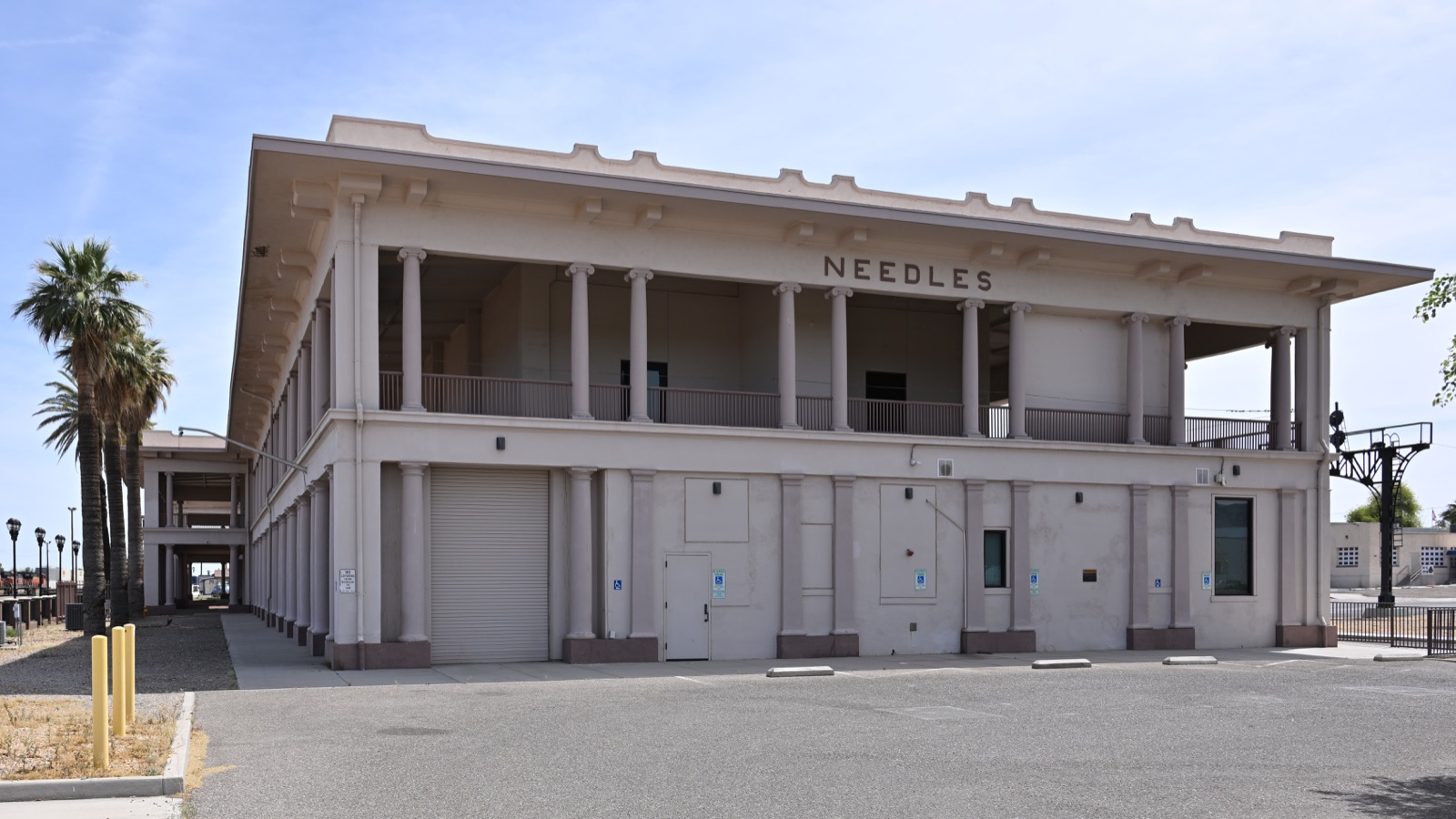
Walk over to El Garces, the Harvey House hotel and Santa Fe depot finished in 1908 and named for Father Francisco Garces, a missionary who came through in 1776. Its columns make it look like a Greek temple dropped in the desert. The City of Needles owns it, spent about $10 million restoring it from 2013, and it now works as the town's Amtrak and transit station. It's been on the National Register since 2002.
Needles is also the hottest stop on the whole route. More on that below, but the short version is that a July afternoon here averages about 110°F.
Goffs and the 1926 road
From 1926 to about 1931, Route 66 didn't follow today's I-40 all the way west of Needles. It left the present interstate line near today's US 95 junction and ran along what is now Goffs Road through the railroad town of Goffs to Essex. In 1931 a more direct road opened between Needles and Essex, and Goffs was bypassed.
The reason to go is the Goffs Schoolhouse, a one-room mission-style school built in 1914 and restored by the Mojave Desert Heritage and Cultural Association. It's now a museum of desert and mining history with outdoor exhibits around it. The museum opens Friday to Sunday, 9 a.m. to 4 p.m., the grounds are open daily, and admission is free. It sits at Lanfair Road and Goffs Road, about 15 miles west of Arrowhead Junction on US 95.
Because the county lists Goffs Road between I-40 and the old road as closed to through traffic, I'd treat Goffs as an out-and-back from US 95 north of Needles, and call the association first at 760-733-4482. It's about 30 miles there and back from the highway, so skip it on a hot summer afternoon.
Essex and Cadiz Summit: the closed stretch
West of Goffs, the old road reaches Essex, a few buildings along the railroad, and then crosses the desert past Danby, Cadiz Summit and Chambless toward Amboy. At Cadiz Summit you can still see the ruins of a stop that once had a gas station, garage, cabins and a cafe.
All of this sits on the closed section. Don't drive around the barricades. This stretch is the reward for a future trip, once the county finishes the bridges.
Amboy and Roy's Motel and Cafe
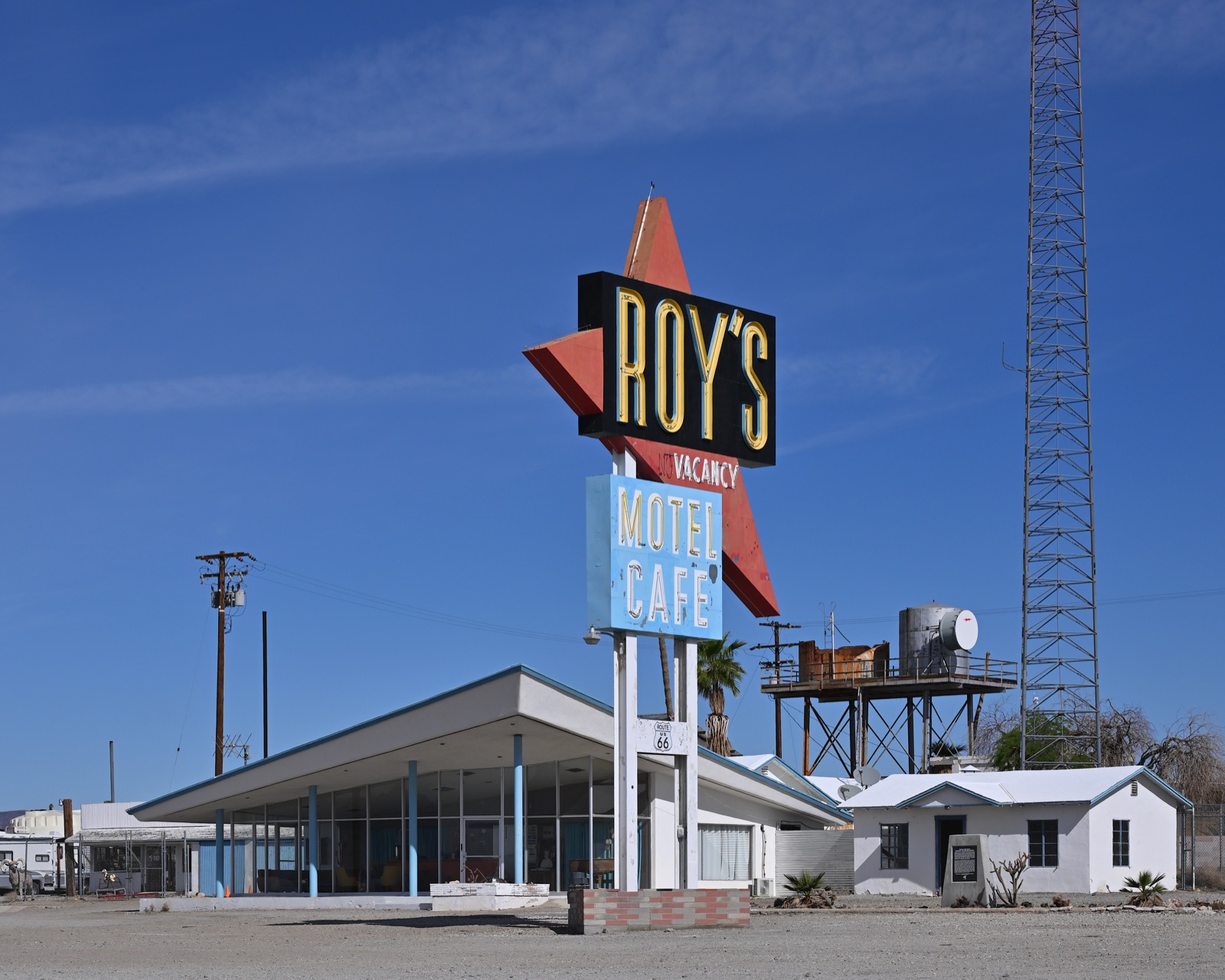
Amboy is the picture everyone wants from the California desert: the Roy's sign standing over an empty road. Roy's opened in 1938, and the boomerang sign went up in 1959. When I-40 bypassed the town in 1973, the traffic disappeared. Albert Okura, who founded the Juan Pollo restaurant chain, bought the whole town in 2005, and his family runs it today.
Don't count on a meal. In June 2026 Roy's was working as a gas station and souvenir shop, with no cafe service, and the motel rooms weren't yet open to guests. Treat its pumps as a backup, never a plan, and bring your own lunch.
Just west of town is Amboy Crater, a cinder cone 250 feet high and 1,500 feet across in one of the youngest volcanic fields in the country. The BLM site has paved parking, a vault toilet, shaded picnic tables, a viewpoint and a trail to the rim, but no running water, and the BLM warns that temperatures climb fast by early afternoon. In the warm months, look from the overlook and don't hike.
Ludlow, Newberry Springs and the Bagdad Cafe
From Amboy, the old road runs 28 miles northwest to Ludlow, a railroad water stop from 1883 that still sells gas and food and has a motel. The Ludlow Cafe is the one place to sit down and eat between Needles and Barstow.
West of Ludlow, National Trails Highway runs beside I-40 through Lavic and Newberry Springs. The Bagdad Cafe, about 20 miles east of Barstow, is the diner from Percy Adlon's 1987 film, and it still draws fans from all over Europe. Andrea Pruett, who ran it for three decades, died in January 2026. The kitchen closed during the pandemic and never reopened. When the Los Angeles Times visited in August 2026, it was selling T-shirts and souvenirs, and the family was still deciding what comes next. Stop for the photo, buy something, and eat in Barstow.
Barstow: the Harvey House and the Mother Road Museum
Barstow is where the desert half ends. It's also where I-40 begins, and where Route 66 once joined US 91 for the run to Los Angeles. One quirk: just east of town, the old road passes through a Marine Corps base, so you're pushed onto I-40 for a short piece near Daggett.
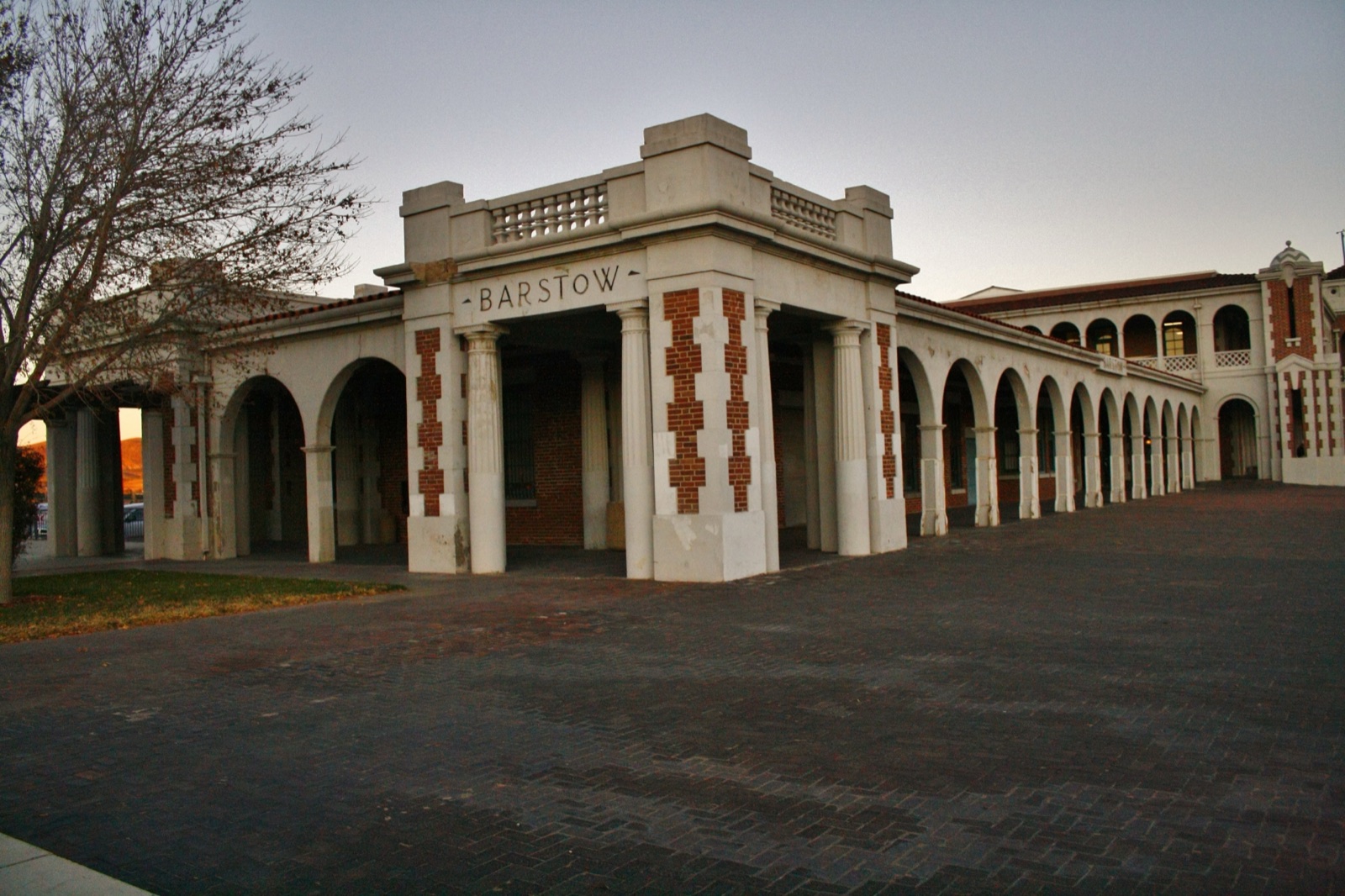
Go to the Harvey House. Casa del Desierto was built in 1911 as a Fred Harvey hotel and Santa Fe depot. Today it's an Amtrak stop and holds two museums, the Western America Railroad Museum and the Route 66 Mother Road Museum. The Route 66 museum closed in June 2024 and has since reopened, but its hours are short: Monday to Saturday, 11 a.m. to 2 p.m., and Sunday, noon to 3 p.m. Plan your morning around that.
Then drive Main Street, which is the old Route 66 and is lined with murals of the town's history. For the night, the Route 66 Motel, with its round beds and old cars in the lot, is on my list of the best Route 66 motels.
Oro Grande and Victorville
From Barstow, take National Trails Highway south along the Mojave River through Helendale and Oro Grande, not I-15. It's one of the nicest pieces of old road in the state.
In Oro Grande, Elmer's Bottle Tree Ranch is about 200 metal "trees" hung with more than 1,000 bottles on two acres beside the road. Elmer Long started it in the early 2000s and kept building until he died in 2019. The people looking after it now have kept the gates open, and it's free. Give it 20 minutes.
In Victorville, the California Route 66 Museum is free and open Monday to Saturday from 10 a.m. to 4 p.m. and Sunday from 11 a.m. to 3 p.m. Nearby, Emma Jean's Holland Burger Cafe has been feeding the road since 1947, breakfast and lunch only, so come early. It's in my guide to the best Route 66 diners.
Cajon Pass and San Bernardino
South of Victorville, the road climbs to Cajon Pass and drops out of the high desert into the Los Angeles basin. Most of the old highway here is buried under I-15, but Cajon Boulevard follows it down in places. The Summit Inn, a diner at the top of the pass since 1952, burned in the Blue Cut Fire on August 16, 2016.
At the bottom, Route 66 enters San Bernardino on Cajon Boulevard and Mount Vernon Avenue. Two food stops: the Mitla Cafe, family run since 1937, and the unofficial museum on E Street at the site of the first McDonald's, owned by the same Okura family that owns Amboy.
Rialto, Fontana and Rancho Cucamonga: Foothill Boulevard
From here to the San Gabriel Valley, Route 66 is Foothill Boulevard, a long, busy commercial street with stoplights every few blocks. The stops are worth the patience.
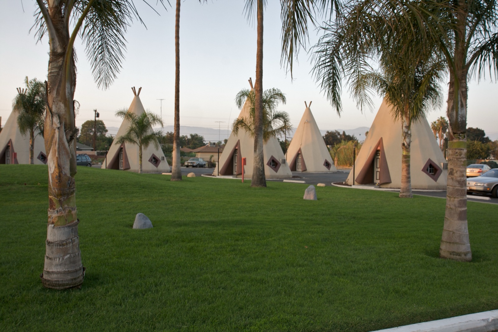
The Wigwam Motel, built in 1949 by Frank Redford's Wigwam Village chain, stands on Foothill Boulevard right on the line between San Bernardino and Rialto. It's one of two Wigwam Motels left on the route, with its twin in Holbrook, Arizona, and it's been on the National Register since 2012. Sleep in a concrete teepee once in your life.
In Fontana, don't go looking for Bono's giant orange, the old juice stand that stood on Foothill. It was moved into storage in 2022, with plans to repair it and put it back nearby.
In Rancho Cucamonga, the Cucamonga Service Station, built in 1915, has been restored as a 1930s Richfield station and runs as a small museum, Thursday to Sunday from 10 a.m. to 4 p.m. A few miles west in Upland, at Foothill and Euclid Avenue, the Madonna of the Trail statue was dedicated on February 1, 1929, to honor pioneer women.
Pasadena and Los Angeles
In Pasadena, Route 66 followed Colorado Boulevard, the city's old main street. In South Pasadena, Fair Oaks Pharmacy, open since 1915, still runs an old-fashioned soda fountain.
Then there's a piece of highway history most people drive without noticing. The Arroyo Seco Parkway between Pasadena and downtown Los Angeles opened in 1940, the first freeway in the western United States, and it became the main line of Route 66. The National Park Service calls it the first stretch of the Mother Road to run on a modern limited-access highway.
From downtown, the old road follows Sunset Boulevard and then Santa Monica Boulevard west through Hollywood and Beverly Hills to the ocean. Until the end of 1935, the road actually ended downtown at Seventh Street and Broadway. Budget real time for this part. Traffic between San Bernardino and the coast can turn 80 miles into an afternoon, and you don't want to reach the pier in the dark.
The end of the trail: Santa Monica
Route 66 ends in Santa Monica in two places. The official end is the corner of Olympic and Lincoln boulevards, where the road was extended on January 1, 1936. The symbolic end is the "Santa Monica 66 End of the Trail" sign on the pier, dedicated on November 11, 2009, the road's 83rd birthday. I stop at Olympic and Lincoln first, then finish on the pier. The details, parking and photo tips are in where Route 66 starts and ends.
Route 66 ghost towns in California
The Mojave stretch has the best-known ghost towns on the whole route. They were railroad stops first, kept alive by highway traffic, and they emptied when I-40 went around them.
- Amboy. Zero permanent residents as of 2024, but not officially a ghost town, because Roy's still sells gas.
- Goffs. A few residents, the schoolhouse museum and the 1926 road. Reach it from US 95.
- Essex, Danby, Cadiz Summit, Chambless. Ruins and a handful of buildings, all on the closed stretch in 2026.
- Ludlow. Half empty, half working: an old hotel and Googie gas station next to a cafe and motel that are still open.
Mojave heat: when to drive California's Route 66
Take the heat seriously. In Needles, the average high is about 87°F in April, 96°F in May, 106°F in June, 110°F in July, 109°F in August and still about 103°F in September, before dropping to about 90°F in October. The record is 125°F. Barstow is cooler but not cool, with July highs around 102°F.
The Park Service at Mojave National Preserve recommends at least one gallon of water per person per day in the car, and two if you're hiking. The BLM, which manages the Mojave Trails National Monument along Route 66, warns that phones don't get a signal everywhere. My rules for the desert:
- Fill up in Needles and again in Barstow, even with half a tank.
- Carry a gallon of water per person, plus extra for the car.
- From May through September, cross the desert early and be off the road by early afternoon.
- Download your maps before you leave Needles.
- If the car breaks down, stay with it and call 911 when you have a signal.
The comfortable months for the desert are spring and fall. I make the case for October in Route 66 in the fall, and I compare every month in the best time to drive Route 66.
Where to sleep on Route 66 in California
- Needles. Fine for a late arrival from Arizona, but book ahead and check reviews, because the River Valley Inn I'd hoped to recommend was closed when I checked it for the Field Manual. RV travelers have the Needles KOA, covered in my Route 66 RV parks guide.
- Barstow. The natural first night. The Route 66 Motel is the one with character.
- San Bernardino. The Wigwam Motel, if you take three days.
- Santa Monica. Expensive, but you'll want to walk to the pier at sunset. If you're in an RV, the camping guide covers the closest RV park to the pier.
If you're timing the trip around the centennial, check my 2026 centennial events calendar for the California dates in November.
Closed, changed or worth a phone call
- National Trails Highway, Kelbaker Road to Essex and Essex to Mountain Springs Road. Closed for bridge replacement. Use I-40 and Kelbaker Road.
- Amboy to Kelbaker Road. Open, with bridge construction until about April 2027. Expect detours and short closures.
- Roy's, Amboy. Gas and souvenirs; no cafe and no motel rooms as of mid-2026.
- Bagdad Cafe, Newberry Springs. Kitchen closed. Souvenirs only, and its future is undecided.
- Route 66 Mother Road Museum, Barstow. Open again, but only three hours a day.
- Goffs Schoolhouse. Museum open Friday to Sunday; call ahead.
- Summit Inn, Cajon Pass. Destroyed by fire in 2016.
- Bono's orange, Fontana. In storage since 2022.
That's how the Field Manual treats the whole route: closed places are marked closed, and anything uncertain is flagged so you call before you drive. For California, the chapter lists nine hotels and nine restaurants on three budgets, with GPS waypoints for the turnoffs you don't want to miss in the desert.
The short version
Fill up in Needles at dawn, take I-40 to Kelbaker Road, and pick up the old road at Amboy. Ride it through Ludlow and past the Bagdad Cafe to a night in Barstow. Next morning, take the river road to the Bottle Tree Ranch, drop over Cajon Pass, crawl along Foothill Boulevard past the wigwams, and finish on the pier. And if you want every stop, map and waypoint for all eight states in one place, the Route 66 Field Manual comes as a printed book and a digital edition in one order. See you at the end of the trail.